Once through The Rockpile, it was an enjoyable ride with the usual sights. Approximately 14 miles into our trip, we crossed into North Carolina, and the route brought us close enough to see the Atlantic Ocean along side of us, as you can see in this photo:

The ocean is at the top--you can even see the surf.
We also passed several inlets (in our case, they would have been outlets) where you can leave the ICW and head out to sea, but we aren't planning to do that on this trip. Here is one inlet we passed:

Once again, we found ourselves admiring the houses along the waterway, at least until we passed this one:

My camera does not do justice to the color of this house--it was really purple and the first really upscale eyesore we have seen, at least until we came across this next one:

What were these people thinking?
Just when we thought we had seen every possible type of housing along the waterways, we came upon our first trailer park:

Fortunately, there were many more interesting homes to view as we went along. There are a lot of new housing developments, and what could be more nautical than a lighthouse at the entrance to your development (even if it has no other purpose?):


Even more new houses line the coast (wonder if they were thinking about hurricanes when they built these right on the Atlantic Ocean?):


Lastly, to sum up the housing part of today's blog, here is one of my favorites:

By mid day, we left the scenic and protected canal section of the ICW and headed onto the Cape Fear River (now there's a name that got my attention). This was another point where you could go right out into the ocean. The wind and waves picked up, as well as the river traffic. No more little yachts floating on the canals--now we were in with the big guys:

There were also a lot of barges, car carriers and tugs to dodge around:

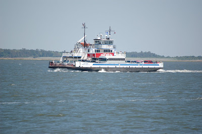


Cute little guy, huh? But it wouldn't take much for him to knock us out of his way and send us to the bottom, so we steered clear of all commercial traffic.
In spite of all that was going on in the river, we navigated the 12 mile stretch before heading back into protected waters, which also meant heading back into potential shallow spots. All went well enough as we headed to our next stop at Wrightsville Beach, until we made the turn into Motts Channel near the marina. Art was going quite slow, but all of a sudden we were going even slower as we scraped the sandy bottom. Fortunately, we coasted on off the sand bar and were able to continue, but three boats after us were not so lucky and had to be towed off. This group included some friends of ours who ended up with a bent prop and had to lay over an extra day for repairs. Luck, and Art's skill, were with us today.


Love it!
ReplyDeleteHave you guys figured out where your going to stop and fly home to see us?
Jackson is so xcited to have grandma's coming to visit him!